 |
TennesseeThe Volunteer State |
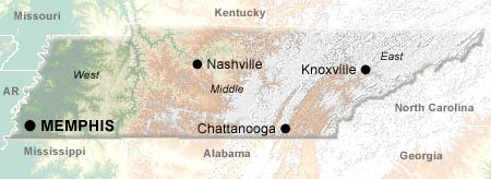
The two largest cities in Tennesse are also two of the most musical cities in America. Nashville is the capital of Country Music, home to such institutions as the Grand Ole Opry, the Country Music Hall of Fame and Museum, and Music Row. Memphis was the birthplace of rock 'n' roll; artists such as Jerry Lee Lewis, B.B. King, Carl Perkins, Johnny Cash, and Elvis Presley cut tracks at the legendary Sun Studios, and Presley's Elvis Presley's Graceland complex draws 600,000 visitors annually.
Outside its cities, Tennessee is known for its lush, green hills and mountains. The Great Smoky Mountains National Park, spread out over Tennessee and North Carolina, is 95% forested. Over 100 species of trees grow on the Smokey's slopes, in addition to thousands of wildflowers, shrubs, and grasses; the park has been designated an International Biosphere Reserve by the U.N. for its diversity.
Tennessee is also known for its rivers. The Ocoee River is an exciting whitewater rafting experience; the Conasauga River has an underwater wildlife viewing area maintained by the state. The Tennessee River was once a rough and wild waterway, but it was tamed by the Tennessee Valley Authority during the 1930s and 40s with a series of dams. The massive project fueled the economic development of communities like Chattanooga with abundant and cheap hydroelectric power; the unnavigable rapids of Muscle Shoals were submerged under 10 feet of water, and huge artificial lakes were formed which are now centers for aquatic recreation.
Cities
Regions
Topics
© 1995-2008 Online Highways, LLC. All rights reserved.